(BPT) - Every construction project, property transaction, infrastructure upgrade and urban planning project begins with one essential requirement: accurate data about the land. That's where land surveys usually come into play. Think of it like a map with legal power — it turns unclear lines on paper into precise measurements on the ground. Surveyors measure and map terrain features, determine property boundaries, calculate elevations and define spatial relationships that guide critical decisions. Without a land survey, decisions are based on assumptions. With a land survey, you have clarity and legal protection.
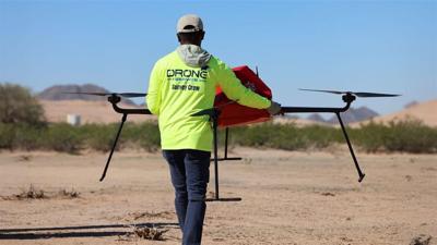
Yet, despite its essential role in modern development projects, land surveying has traditionally remained a "low-tech" industry dominated by a tripod-mounted measurement tool popularized in the 1980s called a "total station." As a result, land surveys can often be time-consuming, hazardous and limited in the type and amount of data they provide. On larger sites or hilly terrains, surveyors usually require multiple days or even weeks to complete a job, and teams frequently operate in risky conditions or difficult-to-access areas: near traffic, on active construction zones and on rooftops. This increases the risk of injury for surveyors while also limiting the efficiency and precision of data collection.
Innovation does exist in the surveying industry, but adoption of modern technologies remains uneven due to costs, difficulty of drone-captured data conversion and regulations. Drone as a Service (DaaS) is changing that by introducing a new variable in the equation: accessibility.
With a fast-growing network of 23 locations across the United States and Europe, DaaS provides commercial and government clients with drone-powered land surveying services. But rather than simply selling drones to customers and letting them deal with the rest, DaaS delivers a fully turnkey solution that modernizes land surveying, while eliminating the barriers that have historically slowed innovation. DaaS users do not need to worry about investing in costly equipment, training pilots or getting the right certifications. From the drones themselves to the licensed pilots and data processing, DaaS handles drone-based land surveys from end to end for customers across industries. By suppressing these key barriers to technology adoption, DaaS opens the door to a new area of efficiency and innovation in the land survey industry.
Faster, safer and more precise: Drones as the key to modernizing land surveying
Leveraging drone technology enables DaaS to dramatically improve speed, precision and safety in land surveys. With the help of drones, what once required days or weeks of fieldwork can often be completed in a fraction of the time. Drone-based surveys conducted by DaaS can map large sites up to 80% faster than traditional ground methods. Instead of waiting sometimes weeks for fragmented insights, stakeholders receive precise deliverables within 24 to 48 hours. For industries operating on tight margins and aggressive timelines, this level of responsiveness can create a decisive competitive advantage.
Beyond speed, drone-based surveys provide more complex and detailed data on the nature and features of a site. DaaS drones are equipped with advanced, interchangeable onboard technologies, including LiDAR (Light Detection and Ranging), multispectral sensors, thermal sensors and photogrammetry systems. These tools allow surveyors to collect high-resolution aerial imagery, detailed 3D models, volumetric measurements and detailed terrain analyses. The result is more comprehensive site intelligence with minimal blind spots and significantly reduced potential for human error. Executives and decision-makers are provided with the insights they need to improve processes, cut costs and meet their targets on time.
From a safety perspective, drone integration represents a significant step forward for the land surveying industry. Rather than exposing surveyors to high-risk environments for extended periods of time, drone surveys can capture full-site coverage quickly and safely. Beyond protecting workers, this reduction in field risk translates into lower liability exposure and fewer unforeseen operational expenses. By minimizing time spent in dangerous work conditions while maximizing data coverage, DaaS enhances both safety and financial performance.
A cross-industry solution built for scale
From commercial buildings and real estate to construction sites and local government public works, many industries rely on land surveys as a basis for their operations. Depending on each project's size, location and specific needs, a survey can take many different forms. In construction, developers rely on accurate topographic, volume and as-built surveys to maintain timelines and budgets. In real estate, boundary and ALTA surveys support transactions and compliance, while local governments and urban planning agencies depend on elevation certificates, right-of-way surveys and wetlands delineation to guide infrastructure and environmental decisions.
DaaS's strength lies in its scalability and adaptability. With 23 locations globally and a diverse drone fleet, the company delivers a broad spectrum of land surveying services, tailoring each survey to site size, terrain conditions, required data outputs and project timelines. Because drones can efficiently scale from small sites to expansive developments across varied terrain, DaaS offers a solution that grows with its customers.
Democratizing the use of drones to drive innovation in "low-tech" industries
Drone as a Service is a business division under parent company ZenaTech. Shaun Passley, Ph.D., the company's CEO, expects to expand the portfolio of drone-based services to include precision agriculture, power-washing, inspection services and warehouse inventory management.
"The extensive capabilities of drones and advanced data, AI and autonomy benefits make them ideal transformation tools for a lot of these traditionally low-tech industries," Passley said. "From inspection and mapping to logistics and improving crop yields, DaaS is at the forefront of this innovation, solving the issue of dull, dirty or dangerous jobs while providing smart data."
The company is leading the way in a global drone services market that's growing at over 36% annually and expected to reach $355 billion by 2032, according to Pragma Market Research. Following the acquisitions of 23 land survey firms in North America over the past year — in Florida, Virginia, California, Oregon, North and South Carolina, Arizona, Colorado, Utah, Illinois and Washington State — the company is growing its network of AI-powered drones in the United States. Combining the decade-long expertise of professional surveyors with drone capabilities, DaaS actively drives innovation in the land surveying industry, and it won't stop there.
By delivering a turnkey, scalable and accessible Drone as a Service model, DaaS is not only modernizing land surveying but also reshaping how essential industries approach data, safety and operational efficiency.